The Eagle Drone has Landed/Ascended: Svaneti
Continuing the adventures of the transcaucasiantrail.org team in Svaneti! And their interactions with one highly bemused transplanted foreigner-resident.
Our heroes (and one heroine too) recently attempted to find the best crossing of one of Etseri’s rivers, the one between us and Pari, in this high-water season. This proved to be difficult, and a bridge will need to be constructed near the Photreri hamlet of Etseri to facilitate crossing. At low-water times, the procedure is much easier, but we’d like to cross whenever we feel like it, right, serendipitous hikers? So, bridge. Put it on the to-do list, please.
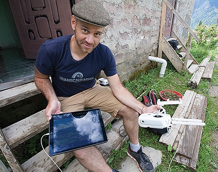
Today Jeff dropped in with a shiny new toy, his quad-copter drone. This is a historic day for me: being a lifelong science fiction enthusiast, and having heard and read about drones for more than a year now, it was the first time I came into personal contact with one of the little flying camera machines. He can link to it via radio from the ground up to 5 km away, and can also program it to make zigzag grid patterns of photographs and then integrate these seamlessly into one gigantic image.
The slick little white thing powered up its four propellers with a loud buzz like an angry hornet, and then just... lifted smoothly into the air. Ascended fast to 120 meters, moved to its mission starting point and began taking photos, sending a confirmation beep for each one along with its location on the grid. The future, in short, had arrived. I was dazzled. Hi Mom, here I am waving at you from the ground in real time, if you like!
Hearing about these things, reading all the gossip about them being shot down by angry Texan neighbors or being used to deliver parcels or as weapons platforms, is one thing. Actually having the machine take off from my front yard, before my wide eyes, is another entirely. On the iPad I could see a little video inset window of its actual progress into the sky and then beginning the grid pattern. It will keep itself steady thanks to those four propellers (if the wind stays normal), and later the stitching software will automatically align and overlap those hundreds of images into one. Now, today, before your eyes.
I was like a kid in a Ray Bradbury novel, every third sentence ending in an exclamation point! The rush of joy was just like that. I’ll never be the same again, and this day will remain in my memory as a life-changer. I can’t downplay it; the anticipation was high, knowing that Jeff would be by sooner or later with the Drone, and suddenly here he was, and me thrilled, never disappointed. Allow me to gush a bit, if you will.
Want a DAILY version of exactly that same map we just made? Done, to show weather and seasonal changes through a whole year, from precisely the same time each day even. Add layers of detail and information, as I wrote here earlier? Up to your imagination. 3D? Go for it! A video tour of your village from the sky? Whatever. These things won’t ever replace you coming here and seeing the place for yourself, I dearly hope; instead, let them only entice you to come experience the reality for yourself, not virtually through some helmet from the safety and comfort of your armchair, but real, tactile, olfactory, audio-video, people-relational real. You know, REAL real. Really.
Tony Hanmer runs the “Svaneti Renaissance” Facebook group, now with over 1300 members, at
www.facebook.com/groups/SvanetiRenaissance/
He and his wife also run their own guest house in Etseri:
www.facebook.com/hanmer.house.svaneti
Tony Hanmer


